
A total of 13 walks planned for this trip to Scotland staying in 3 separate locations over nearly a two week period. Taking account of changeover days, sightseeing days and just doing nothing days, we expect to do 6 or 7 walks depending on weather and fitness.
The first location is a bit of a surprise from me to Gina staying at a mystery Inn, located on the edge of a loch and miles from anywhere, as a mark of appreciation to her for agreeing to do a few Munros with me.
The second location is a rented house in Kinlochleven. We first visited here on our last trip, when we walked part of the West Highland Way from Lundavra to Kinlochleven. We thought it was a lovely location; in particular the bus ride along Loch Leven seemed to reveal a spectacular view around every corner, which the school kids just seemed to take in their stride.
Finally we will have a couple of days back at Laurel Bank Lodge where we stayed during our two visits back in 2012. We have always been looked after very well by our hosts, Steve & Brenda and feel our visit to the Fort William area would not be complete without spending at least a couple of days here.
In all three locations there are more walks planned than planned walking days, but that only serves to cover all options in terms of weather, local conditions and how we feel. Primarily we will be looking to go on the walks with a Munro included in the list. There are two walks per location that include a Munro and these have been chosen for their relative ease of accessibility, however depending on the weather and conditions there is not always an easy Munro so we may have to make do with a Corbett on one of these two walks. Failing that I have planned walks to include a Graham and failing that a further walk to visit a nearby Highland 5. This level of planning may seem an over indulgence but Gina’s level of tolerance to adverse conditions, if not less than mine is more cautious, and while it can sometimes be frustrating is most likely for the best.
All in all, including rest/contingency days, I reckon we have a walk planned to cover most conditions apart from horrendous weather. That said, if we do not manage at least one walk at each one of the locations the weather will have to be so bad you would not send a dog out in the conditions and in that case we will be taking full advantage of the roaring fire or other excellent facilities available at our lodgings.
Biod an Fhithich
Route

Route Profile

Start Point - Kinlochleven (GR - NN 18590 62155)
Start Height - 12.45m
Finish Point - Kinlochleven (GR - NN 18590 62155)
Finish Height - 12.45m
Distance Walked - 10.06miles
Height Ascended - 1353.35metres
Duration - 7hrs 52mins [based on average pace 1.75mph + 1hr 0mins added per 600m of ascent]
Route

Route Profile

Meall Beag & Meall na Duibhe
Route

Route Profile

Mam na Gualainn
Route

Route Profile

Tom Meadhoin
Route

Route Profile
Nevis Range
Route

Route Profile

Sgorr na Ciche [Pap of Glencoe]
Route

Route Profile
Fort William
Mullach nan Coirean
Route

Route Profile

Stob Bàn
Route

Route Profile

The first location is a bit of a surprise from me to Gina staying at a mystery Inn, located on the edge of a loch and miles from anywhere, as a mark of appreciation to her for agreeing to do a few Munros with me.
The second location is a rented house in Kinlochleven. We first visited here on our last trip, when we walked part of the West Highland Way from Lundavra to Kinlochleven. We thought it was a lovely location; in particular the bus ride along Loch Leven seemed to reveal a spectacular view around every corner, which the school kids just seemed to take in their stride.
Finally we will have a couple of days back at Laurel Bank Lodge where we stayed during our two visits back in 2012. We have always been looked after very well by our hosts, Steve & Brenda and feel our visit to the Fort William area would not be complete without spending at least a couple of days here.
In all three locations there are more walks planned than planned walking days, but that only serves to cover all options in terms of weather, local conditions and how we feel. Primarily we will be looking to go on the walks with a Munro included in the list. There are two walks per location that include a Munro and these have been chosen for their relative ease of accessibility, however depending on the weather and conditions there is not always an easy Munro so we may have to make do with a Corbett on one of these two walks. Failing that I have planned walks to include a Graham and failing that a further walk to visit a nearby Highland 5. This level of planning may seem an over indulgence but Gina’s level of tolerance to adverse conditions, if not less than mine is more cautious, and while it can sometimes be frustrating is most likely for the best.
All in all, including rest/contingency days, I reckon we have a walk planned to cover most conditions apart from horrendous weather. That said, if we do not manage at least one walk at each one of the locations the weather will have to be so bad you would not send a dog out in the conditions and in that case we will be taking full advantage of the roaring fire or other excellent facilities available at our lodgings.
Distance
|
Height
Climbed
|
||||||
Walk
Title
|
(miles)
|
(metres)
|
Munro
|
Munro Tops
|
Corbett
|
Graham
|
Highland 5
|
CLUANIE INN (4 walks for 2 day visit)
|
|||||||
Ciste
Dhubh
|
10.02
|
1139.39
|
Ciste Dhubh
|
Ciste Dhubh
|
|||
Am Bathach
|
|||||||
Sgurr
nan Conbhairean & Carn Ghluasaid
|
9.27
|
1219.47
|
Carn Ghluasaid
|
Carn Ghluasaid
|
|||
Sgurr nan Conbhairean
|
Sgurr nan Conbhairean
|
||||||
Creag a'Chaorainn
|
|||||||
Drochaid an Tuill Easaich
|
|||||||
Biod an
Fhithich
|
6.20
|
701.69
|
Biod an Fhithich
|
||||
A'Mhuing
|
|||||||
Maol
Disnich
|
5.16
|
410.15
|
Maol Disnich
|
||||
KINLOCHLEVEN (6/7 walks for 6 day visit)
|
|||||||
Sgurr
Eilde Mor
|
10.06
|
1353.35
|
Binnein Mor - Sgor Eilde Beag
|
||||
Sgurr Eilde Mor
|
Sgurr Eilde Mor
|
||||||
Meall
Beag & Meall na Duibhe
|
9.05
|
839.77
|
Meall Beag
|
||||
Meall na Duibhe
|
|||||||
Mam na
Gualainn
|
8.48
|
1050.28
|
Mam na Gualainn
|
||||
Mam na Gualainn East Top
|
|||||||
Beinn na Caillich
|
|||||||
Tom
Meadhoin
|
7.86
|
902.25
|
Doire Ban
|
||||
Tom Meadhoin
|
|||||||
Creag Bhreac
|
|||||||
Nevis
Range
|
6.97
|
966.48
|
Sgurr Finnisg-aig
|
||||
Aonach Mor
|
Aonach Mor
|
||||||
Aonach Beag
|
Aonach Beag
|
||||||
Pap of
Glencoe
|
4.32
|
727.94
|
Sgorr na Ciche [Pap of Glencoe]
|
||||
FORT WILLIAM (3 walks for 1/2 day visit)
|
|||||||
Mullach
nan Coirean
|
10.70
|
1120.29
|
Meall a'Chaorainn
|
||||
Mullach nan Coirean
|
Mullach nan Coirean
|
||||||
Mullach nan Coirean SE Top
|
|||||||
Mullach nan Coirean East Top
|
|||||||
Stob
Bàn
|
8.29
|
1306.22
|
Stob Bàn
|
Stob Bàn
|
|||
Lochan Coile e nam Miseach
|
|||||||
Inchree
Falls - Lundavra
|
7.96
|
1071.68
|
Beinn na Gucaig SW Top
|
||||
Beinn na Gucaig
|
|||||||
Doire Ban
|
|||||||
104.34
|
12808.96
|
8
|
13
|
5
|
7
|
6
|
Cluanie Inn
Ciste Dhubh
Route Information
Start Point - Cluanie Inn (GR - NH 07665 11772)
Start Height - 227.05m
Finish Point - Cluanie Inn (GR - NH 07665 11772)
Finish Height - 227.05m
Distance Walked - 9.29miles
Height Ascended - 1215.13metres
Duration - 7hrs 31mins [based on average pace 1.75mph + 1hr 0mins added per 600m of ascent]
Route

Route Profile

Sgurr nan Conbhairean & Carn Ghluasaid
Route

Route Profile

Route Information
Start Point - Cluanie Inn (GR - NH 07665 11772)
Start Height - 227.05m
Finish Point - Cluanie Inn (GR - NH 07665 11772)
Finish Height - 227.05m
Distance Walked - 9.29miles
Height Ascended - 1215.13metres
Duration - 7hrs 31mins [based on average pace 1.75mph + 1hr 0mins added per 600m of ascent]
Route

Route Profile

Sgurr nan Conbhairean & Carn Ghluasaid
Route Information
Start Point - Old Military Road nr Cruachan Coille a' Chait (GR - NH 11195 11070)
Start Height - 259.55m
Finish Point - Old Military Road nr Cruachan Coille a' Chait (GR - NH 11195 11070)
Finish Height - 259.55m
Distance Walked - 9.29miles
Height Ascended - 1077.22metres
Duration - 7hrs 13mins [based on average pace 1.75mph + 1hr 0mins added per 600m of ascent]
Route

Route Profile

Biod an Fhithich
Route Information
Start Point - Achadh Arsgalain Quarry (GR - NG 96362 14770)
Start Height - 24.85m
Finish Point - Achadh Arsgalain Quarry (GR - NG 96362 14770)
Finish Height - 224.85m
Distance Walked - 6.20miles
Height Ascended - 701.69metres
Duration - 4hrs 38mins [based on average pace 1.75mph + 1hr 0mins added per 600m of ascent]
Route

Route Profile

Maol Disnich
Route
Route Profile
Route Information
Start Point - Cluanie Inn (GR - NH 07665 11772)
Start Height - 227.05m
Finish Point - Cluanie Inn (GR - NH 07665 11772)
Finish Height - 227.05m
Start Height - 227.05m
Finish Point - Cluanie Inn (GR - NH 07665 11772)
Finish Height - 227.05m
Distance Walked - 5.16miles
Height Ascended - 410.15metres
Duration - 3hrs 36mins [based on average pace 1.75mph + 1hr 0mins added per 600m of ascent]
Route
Route Profile
Kinlochleven
Sgurr Eilde Mor
Route InformationStart Point - Kinlochleven (GR - NN 18590 62155)
Start Height - 12.45m
Finish Point - Kinlochleven (GR - NN 18590 62155)
Finish Height - 12.45m
Distance Walked - 10.06miles
Height Ascended - 1353.35metres
Duration - 7hrs 52mins [based on average pace 1.75mph + 1hr 0mins added per 600m of ascent]
Route

Route Profile

Meall Beag & Meall na Duibhe
Route Information
Start Point - Kinlochleven (GR - NN 18590 62155)
Start Height - 12.45m
Finish Point - Kinlochleven (GR - NN 18590 62155)
Finish Height - 12.45m
Distance Walked - 9.05miles
Height Ascended - 839.77metres
Duration - 6hrs 30mins [based on average pace 1.75mph + 1hr 0mins added per 600m of ascent]
Route

Route Profile

Mam na Gualainn
Route Information
Start Point - Callert House (GR - NN 09245 60270)
Start Height - 10.56m
Finish Point - Kinlochleven (GR - NN 18590 62155)
Finish Height - 12.45m
Distance Walked - 8.48miles
Height Ascended - 1050.28metres
Duration - 6hrs 30mins [based on average pace 1.75mph + 1hr 0mins added per 600m of ascent]
Route

Route Profile

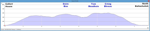
Tom Meadhoin
Route Information
Start Point - Callert House (GR - NN 09245 60270)
Start Height - 10.56m
Finish Point - North Ballaculish (GR - NN 05240 60402)
Finish Height - 8.51m
Distance Walked - 7.89miles
Height Ascended - 903.44metres
Duration - 5hrs 56mins [based on average pace 1.75mph + 1hr 0mins added per 600m of ascent]
Route

Route Profile

Nevis Range
Route Information
Start Point - Adventure Activity Centre (GR - NN 18590 62155)
Start Height - 651.35m
Finish Point - Adventure Activity Centre (GR - NN 18590 62155)
Finish Height - 651.35m
Distance Walked - 6.97miles
Height Ascended - 966.48metres
Duration - 5hrs 29mins [based on average pace 1.75mph + 1hr 0mins added per 600m of ascent]
Route

Route Profile

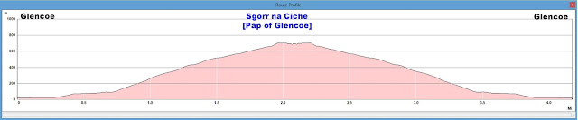
Sgorr na Ciche [Pap of Glencoe]
Route Information
Start Point - Glencoe (GR - NN 10710 58767)
Start Height - 19.89m
Finish Point - Glencoe (GR - NN 10710 58767)
Finish Height - 19.89m
Distance Walked - 4.32miles
Height Ascended - 728.03metres
Duration - 3hrs 35mins [based on average pace 1.75mph + 1hr 0mins added per 600m of ascent]
Route

Route Profile

Fort William
Mullach nan Coirean
Route Information
Start Point - Blàr a' Chaorainn [ruin] (GR - NN 10025 66632)
Start Height - 166.13m
Finish Point - Blàr a' Chaorainn [ruin] (GR - NN 10025 66632)
Finish Height - 166.13m
Distance Walked - 10.70miles
Height Ascended - 1120.29metres
Duration - 7hrs 53mins [based on average pace 1.5mph + 1hr 0mins added per 600m of ascent]
Route

Route Profile

Route Information
Start Point - Lower Polldubh Falls car park (GR - NN 14520 68332)
Start Height - 57.03m
Finish Point - Lower Polldubh Falls car park (GR - NN 14520 68332)
Finish Height - 57.03m
Distance Walked - 8.29miles
Height Ascended - 1306.22metres
Duration - 6hrs 46mins [based on average pace 1.5mph + 1hr 0mins added per 600m of ascent]
Route

Route Profile

Inchree Falls to Lundavra
Route


Route Information
Start Point - Inchree (GR - NN 02460 62912)
Start Height - 16.06m
Finish Point - Lundavra (GR - NN 09442 66440)
Finish Height - 169.23m
Distance Walked - 7.96miles
Height Ascended - 1071.68metres
Duration - 6hrs 15mins [based on average pace 1.5mph + 1hr 0mins added per 600m of ascent]
Route

Route Profile

No comments:
Post a Comment